
BioMechanical Engineer
Accident Reconstructionist

Director of Business Development
Western & Mid-Atlantic Region
Preserving an accident scene is the number one priority for a forensic engineering investigation. When an accident occurs and CED Technologies receives a case, the first step is to schedule an inspection of the scene with the most qualified forensic engineer. Until recently, forensic engineers had to follow a somewhat painstaking procedure to perform a complete inspection. Upon arrival at the scene, the engineer had to take numerous photos and measurements – as precise as possible with basic tools like measuring tape and the naked eye – and manually sketch out the scene by hand. The process is known as preserving, or memorializing, the scene. This site documentation enables forensic engineers to thoroughly reconstruct the accident to determine causation. Based on CED’s investigation of the scene and a review of documents to include testimony, causation can then be categorized to three scenarios: design limitations (or flaws), human error, or environmental factors. Simply put, was the accident a result of user error or manufacturer error?
In the weeks following an accident and the period leading up to a trial, the evidence may change due to environmental or other factors and the memory of what exactly occurred may fade. If performed correctly, preserving the scene can solve this problem and can prove crucial in many cases. In civil cases, an accusation against a defendant must be substantiated and proven within a reasonable degree of (engineering) certainty. Therefore, the preservation or handling of evidence can be a major factor for the results of a civil trial.
Enter the latest generation of high-tech tools which are now at our disposal, and increasingly admissible in legal proceedings. High resolution 3-D laser scanners, rapid LiDAR scanning, advanced photogrammetry, and GPS enabled photogrammetry using drones and phones are completely changing the landscape, providing near fool-proof data that serves as indisputable evidence.
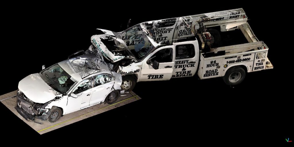
The Faro 3D Laser Scanner is a tool which uses lasers and can map out everything in an entire area with millimeter accuracy. From its perch on a tripod, millions of individual data points can be captured in a 360-degree line of sight scan at a resolution of 1 to 2 millimeters. Using proprietary software, each scan is set up and processed to create a demonstrative 3D model. Multiple scans can be stitched together to create a final rendering of a complete scene or building. The scanner can be placed in any accident scene including roadway collisions, construction mishaps, building fires, and industrial equipment accidents.
Using math formulas and engineering, forensic engineers at CED solve the accident “puzzle” by piecing together the events that occurred right before, during, and after the accident scenario. One of the greatest benefits to laser scanning technology is that the scene is permanently and accurately frozen in time, so that engineers can perform detailed reconstruction of the scene over an extended period. They can go back at any time and take additional measurements if they missed one; they have access to trillions of measurements due to the abundance of data-rich detail captured by the scanner. The scene can be analyzed from various angles, views, and vantage points.
Take the case of a worker who falls off a scissor lift at an electrical substation. Thanks to the Faro scanner, an engineer can solve the puzzle of why the accident happened by working backward and revisiting the model created by the scans. Was it due to a physical environmental factor like sloped ground? Was it a design flaw, where the equipment broke? Or was it an unforeseeable or unpredictable cause which the engineer had not initially considered — but suddenly can solve the puzzle when an obstacle is discovered in the 3D model when viewed from another vantage point or after another measurement is taken.
How about a highway accident involving multiple vehicles? Because the accident scene can be captured and documented as soon as the forensic engineer steps on site for later inspection and analysis, law enforcement offices commonly invest in laser scanners in the hopes of eliminating traffic gridlock nightmares due to prolonged road closures, which are estimated to cost the US economy billions of dollars per year. When serious accidents occur on highways, measuring the geometry of the scene is what takes time. With the scanners, documenting and preserving the scene can now literally be done in a matter of minutes, instead of hours so that traffic can get moving again. (https://www.youtube.com/watch?v=HyS5bEOK7CU).
The panoramic photographs and precisely measured models enable engineers to create incredibly accurate visuals, simulations and animations which can be tailored to any type of investigation. For this reason, this scanner has been dubbed the “ultimate documenting tool” for court proceedings; juries love to see the renderings. It captures the most details with the best accuracy.
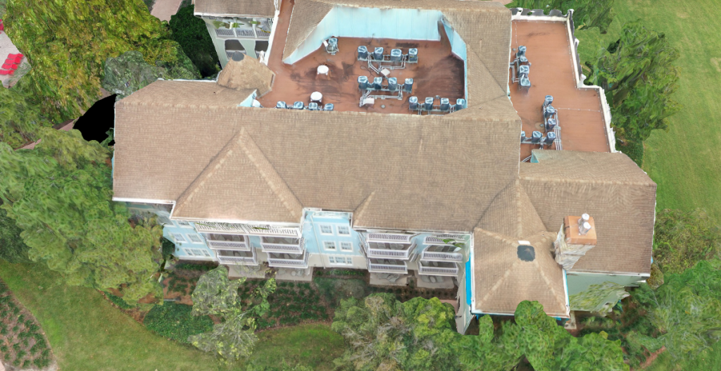
In cases where larger scenes take up longer stretches or more acreage, flying drones with high resolution cameras is likely to be the ideal technique instead of 3D scanners. Drones employ photogrammetry, which is the use of photography in surveying and mapping to measure distances between objects. While a drone flies over a scene, hundreds of photographs are captured with high-quality cameras. Each photograph is tagged with GPS coordinates and altitude to orient the photograph in 3D space. These photos are then combined to create an accurate geometrical layout of an area with elevation and 3D object profiles. While 3D laser scans are stationary and take time to collect all data within one area, drones collect data over a much larger area quickly and efficiently.

Gavin O’Hare, of CED Technologies, states, “The use of drones or aerial photography represents a quantum leap in measurement methods and technology. A ten-minute flight of a drone will capture hundreds of pictures and a large swath of real estate. These pictures can then be used to construct a 3D model that has a variety of uses. The overhead map view or 3D model view can be uploaded to a website that can be viewed by interested parties who have access to the internet. Additionally, live drone video taken can be screen shared to the web where interested parties far away can also participate in an inspection.” 3D panoramic views can also be captured and easily shared with interested parties.
Drones are very commonly used for roof repair estimates and inspections, particularly by civil engineers in Florida and other southeastern states where hurricanes and tropical storms wreak frequent havoc. Property insurance rates have skyrocketed in those regions in recent years due to the massive number of storm damage claims. Inspections via drone are quick, efficient and provide very accurate measurements (though not quite as accurate as the 3D scanners). It is important to note that although drone usage is federally regulated through the FAA, each state has its own laws regulating their use, and drones may not be allowed in certain restricted airspace zones.
Another helpful tool for capturing scenes is to use LiDAR technology especially for situations when drones cannot be flown, and rapid measurement is desired. LiDAR is an acronym for “light detection and ranging.” LiDAR technology also employs the use of lasers to measure objects but can be deployed on a movable device such as a phone or tablet. Longer range LiDAR is used to make 3-D representations of areas on the earth’s surface and ocean bottom. For accident reconstruction purposes, it is commonly used to make 3D models of vehicles and layouts of buildings. LiDAR is also used in control and navigation for some autonomous cars and tractor-trailers, and for the helicopter Ingenuity on its record-setting flights over the terrain of Mars (https://en.m.wikipedia.org).
LiDAR technology has recently become available on certain tablets and phones for 3D mapping; but not all have the technology built in. The fidelity of recreated views using LiDAR is less than those taken by the stationary high-resolution laser scanners like the FARO, but the LiDAR enabled devices allow investigators to quickly walk around the scene or a piece of evidence such as an accident vehicle. Then, they can build a rapid 3D model that can be shared on the web and used later for demonstrative evidence, as with the previous technologies. This rapid LiDAR technology builds a demonstrative quickly and can capture more details than GPS enabled digital cameras, discussed below.
GPS enabled photographs can also be taken on a camera, phone or tablet, and similar to drones, can be combined using photogrammetry to create 3D models of scenes or evidence. The photos are processed with specialized software to build the 3D models but not as accurately as LiDAR and laser scanners do. The newest technology and software combine the use of LiDAR and photogrammetry using the latest phones and tablets thus creating a higher accuracy model than just using one or the other. Even though the end results from these cameras result in a visual model with slightly less fidelity than the other technologies described in this paper, a camera has the advantage of being handheld and can therefore be used in tight spots where the 3D scanner, which must be mounted on a tripod, cannot. Thus, a GPS tagged camera or phone is arguably the most “user friendly” tool to have on hand.
These technologies help experts build accurate demonstrative evidence without the need to have a graphic artist paint a picture. The usefulness of these tools is measured by how efficiently and accurately they can capture and accident scene or evidence. The use of engineering methods to measure objects in 3D space from photographs and lasers has been well documented and the accuracy of each technology can be validated by hands-on direct measuring of the evidence that is being imaged. With modern technology, these methods are only further enhanced and more reliable.
References:
St. Charles County Police FARO 3D Scanner for Crime Scene Investigation https://youtu.be/XCDzkb2zrhE
3D Laser Scanner, Police, Accident and Crime Scene Investigation https://youtu.be/HyS5bEOK7CU
Think 3D Drone Scanning with FARO Laser Scanner Focus 3D X130: STORMBEE https://youtu.be/qdqQmjUk3IM
Timothy M. Ravich, Courts in the Drone Age, 42 N. Ky. L. Rev. 161 (2015).
James Michael Shaw, Jr. & Ryan K. Hilton, Flying Witnesses: Admissibility of Drone-Gathered Evidence in Florida, Trial Advoc. Q., Winter 2016, at 21 (2016).
Insurance Industry Drone Use is Flying Higher and Farther, Deloitte., https://www2.deloitte.com/us/en/pages/financial-services/articles/infocus-drone-use-by-insurance-industry-flying-higher-farther.html (last visited July 28, 2021).
2015 Innovation Awards – Faro Crime Scene Scanner
https://www.youtube.com/watch?v=3sBPTt1DZ0w